Difference between revisions of "Sambava to Andapa by bike"
CampMaster (talk | contribs) |
CampMaster (talk | contribs) |
||
| Line 1: | Line 1: | ||
| − | '''The incredibly scenic bike route from Sambava to Andapa can be a challenging one, not because of the road condition or necessarily the 110 | + | '''The incredibly scenic bike route from Sambava to Andapa can be a challenging one, not because of the road condition or necessarily the 110-kilometre distance, but because of the gradually increasing intensity and regularity of uphills, especially along the final 20 kilometres. The rough stone tarmac road is in perfect condition and passing cars are few and far between.''' |
[[File:Sambava_to_Andapa_by_bike_072.jpg|600px|link=Sambava_to_Andapa_by_bike_map]] | [[File:Sambava_to_Andapa_by_bike_072.jpg|600px|link=Sambava_to_Andapa_by_bike_map]] | ||
| Line 44: | Line 44: | ||
</div> | </div> | ||
| − | The entire stretch is surrounded by | + | The entire stretch is surrounded by mountainous landscapes, traditional farming and picturesque villages some including the French colonial era built bridges crossing rivers. There are at least one or two weekly markets along the route on any given day of the week. |
{| class="imageTable" | {| class="imageTable" | ||
| Line 59: | Line 59: | ||
<HTML5video type="youtube">playlist?list=PL2PUMu_dznnZCezOKn65J6jylcTt-Jfhk</HTML5video> | <HTML5video type="youtube">playlist?list=PL2PUMu_dznnZCezOKn65J6jylcTt-Jfhk</HTML5video> | ||
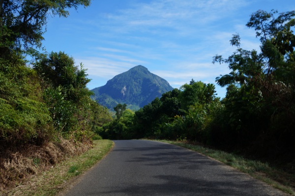
| − | Throughout much of the ride, countless views Marojejy massif with its 2,132 metres peak is part of the scenery. | + | Throughout much of the ride, countless views of Marojejy massif with its 2,132 metres peak is part of the scenery. |
{| class="imageTable" | {| class="imageTable" | ||
| Line 71: | Line 71: | ||
|} | |} | ||
| − | Every few kilometres there are villages but none which offers high standard accommodation, so it's best to complete the entire stretch in one day, perhaps arriving at the Andapa peak by sunset. | + | Every few kilometres there are villages but none of which offers high standard accommodation, so it's best to complete the entire stretch in one day, perhaps arriving at the Andapa peak by sunset. |
[[File:Sambava_to_Andapa_by_bike_164.jpg|600px]] | [[File:Sambava_to_Andapa_by_bike_164.jpg|600px]] | ||
| Line 95: | Line 95: | ||
|} | |} | ||
| − | Thereafter, only a 10-minute downhill roll until the finishing line, where the best accommodation in town, [[Hotel Beanana]], is located shortly before the town hall and figurehead statue. Hotel Beanana offers hot water which, as it gets chilly at night in this region. There is no restaurant. Meals, | + | Thereafter, only a 10-minute downhill roll until the finishing line, where the best accommodation in town, [[Hotel Beanana]], is located shortly before the town hall and figurehead statue. Hotel Beanana offers hot water which, as it gets chilly at night in this region. There is no restaurant. Meals, including breakfast, can however be preordered. |
{| class="imageTable" | {| class="imageTable" | ||
| Line 107: | Line 107: | ||
|} | |} | ||
| − | Foreign visitors usually come to this part of Madagascar to visit [[Marojejy National Park]], which offers a | + | Foreign visitors usually come to this part of Madagascar to visit [[Marojejy National Park]], which offers a stopover for bikers wishing to break the ride into two parts. |
{| class="imageTable" | {| class="imageTable" | ||
| Line 119: | Line 119: | ||
|} | |} | ||
| − | Marojejy has camp tents at three different elevations | + | Marojejy has camp tents at three different elevations. Marojejy's office can be found shortly before [[Manantenina]] where bikes may also be stored during visits to the park. Information about available circuits is available here as well as guides to the park. |
[[File:Sambava_to_Andapa_by_bike_111.jpg|600px]] | [[File:Sambava_to_Andapa_by_bike_111.jpg|600px]] | ||
| − | After Manantenina, in the villa of [[Ambohimanarina]], Mr Kakao, has a restaurant (at S 14°30.457' E049°49.027'), which over halfway to Andapa makes a good lunch stop before embarking on the | + | After Manantenina, in the villa of [[Ambohimanarina]], Mr Kakao, has a restaurant (at S 14°30.457' E049°49.027'), which over halfway to Andapa makes a good lunch stop before embarking on the remaining and challenging uphills. |
{| class="imageTable" | {| class="imageTable" | ||
| Line 139: | Line 139: | ||
[[File:Sambava_to_Andapa_by_bike_425.jpg|600px]] | [[File:Sambava_to_Andapa_by_bike_425.jpg|600px]] | ||
| − | Combining the uphills and downhills between Sambava and Andapa, the total ascent is 1,536 metres and the total descent is 1,054 metres. Towards the latter part and for | + | Combining the uphills and downhills between Sambava and Andapa, the total ascent is 1,536 metres and the total descent is 1,054 metres. Towards the latter part and for most people except the athlete biker, a good few uphills will require leading the bike. |
<HTML5video type="youtube">AWhGv3H-L2w</HTML5video> | <HTML5video type="youtube">AWhGv3H-L2w</HTML5video> | ||
| − | As of 2022, Andapa Basin is a virtually tourist-free zone, not due | + | As of 2022, Andapa Basin is a virtually tourist-free zone, not due to a lack of attractions, but because the destination has remained below the radar of the tourism industry and what is typically offered by package tour operators. |
[[File:Sambava_to_Andapa_by_bike_027.jpg|600px]] | [[File:Sambava_to_Andapa_by_bike_027.jpg|600px]] | ||
| − | To explore the area | + | To explore the area further afield, for example, complete a 26-kilometre bike ride from Andapa to [[Ampontsilahy]] and return. |
{| class="imageTable" | {| class="imageTable" | ||
| Line 173: | Line 173: | ||
|} | |} | ||
| − | The return part to Sambava with | + | The return part to Sambava with fewer uphills than downhills, especially the first kilometres, is an all-scenic rollercoaster. |
<HTML5video type="youtube">tUtAIYN2VcI </HTML5video> | <HTML5video type="youtube">tUtAIYN2VcI </HTML5video> | ||
Find more bike routes at [[Madabike#Preloaded_GPS_routes|MadaBike]]. | Find more bike routes at [[Madabike#Preloaded_GPS_routes|MadaBike]]. | ||
Revision as of 15:28, 4 September 2022
The incredibly scenic bike route from Sambava to Andapa can be a challenging one, not because of the road condition or necessarily the 110-kilometre distance, but because of the gradually increasing intensity and regularity of uphills, especially along the final 20 kilometres. The rough stone tarmac road is in perfect condition and passing cars are few and far between.
After about eight kilometres along the RN5a from Sambava, turn left at the crossroad village of Ambariomihambana where the RN3b way to Andapa begins.
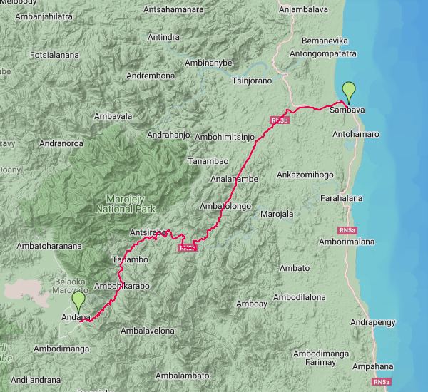
Sambava - Ambariomihambana - Ankorabe - Antsohorana - Bekona - Ambohimalaza - Antsahalalina - Mahitsiarongana - Ambodivohitra - Lohanantsahabe - Sarahandrano - Antsahabe - Manakana - Ambodiampana - Tananbao 5 - Maroambihy - Manantenina - Ambohimanarina - Anjabe - Amboaginbe Lokoho - Andranomifotitra - Andranfytrya - Belambo Lokoho - Antanambao Lokoho - Ambalavoanio Lokoho - Belaoko Lokoho - Ambahinkarabo - Andrakata - Masiaposa - Andapa
The entire stretch is surrounded by mountainous landscapes, traditional farming and picturesque villages some including the French colonial era built bridges crossing rivers. There are at least one or two weekly markets along the route on any given day of the week.

| ||

|

|

|
Throughout much of the ride, countless views of Marojejy massif with its 2,132 metres peak is part of the scenery.

| ||

|

|

|
Every few kilometres there are villages but none of which offers high standard accommodation, so it's best to complete the entire stretch in one day, perhaps arriving at the Andapa peak by sunset.


Andapa Basin, named so in reference to its surrounding mountain range and frequent rainfall, will be in view shortly after the highest point of the road at 737 metres.

| ||

|

|

|

| ||
Thereafter, only a 10-minute downhill roll until the finishing line, where the best accommodation in town, Hotel Beanana, is located shortly before the town hall and figurehead statue. Hotel Beanana offers hot water which, as it gets chilly at night in this region. There is no restaurant. Meals, including breakfast, can however be preordered.

| ||

|

|

|
Foreign visitors usually come to this part of Madagascar to visit Marojejy National Park, which offers a stopover for bikers wishing to break the ride into two parts.

| ||

|

|

|
Marojejy has camp tents at three different elevations. Marojejy's office can be found shortly before Manantenina where bikes may also be stored during visits to the park. Information about available circuits is available here as well as guides to the park.
After Manantenina, in the villa of Ambohimanarina, Mr Kakao, has a restaurant (at S 14°30.457' E049°49.027'), which over halfway to Andapa makes a good lunch stop before embarking on the remaining and challenging uphills.

| ||

|

|

|
The Andapa Basin itself offers bike and trekking opportunities in all directions. Except for in Andapa town, there are no tarmac roads, only countryside roads and trails.

Combining the uphills and downhills between Sambava and Andapa, the total ascent is 1,536 metres and the total descent is 1,054 metres. Towards the latter part and for most people except the athlete biker, a good few uphills will require leading the bike.
As of 2022, Andapa Basin is a virtually tourist-free zone, not due to a lack of attractions, but because the destination has remained below the radar of the tourism industry and what is typically offered by package tour operators.

To explore the area further afield, for example, complete a 26-kilometre bike ride from Andapa to Ampontsilahy and return.

| ||

|

|

|
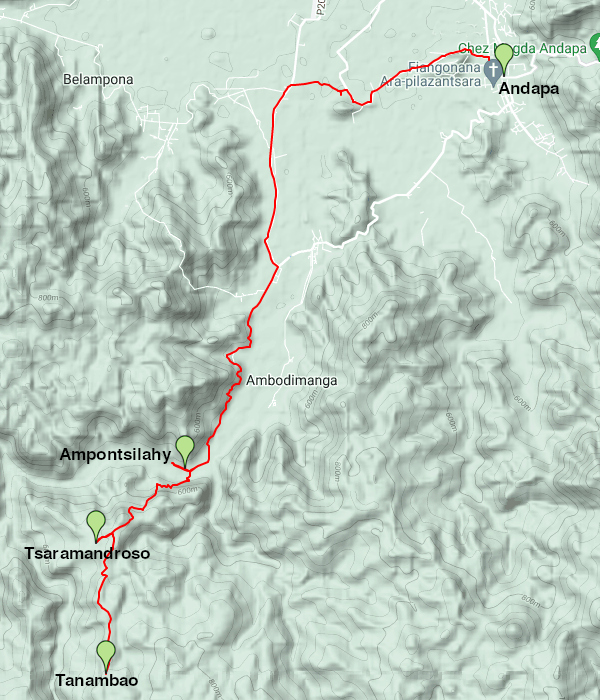
Alternatively, stay overnight at the basic accommodation in Ampontsilahy and thereafter continue by foot along the less bikable routes at higher elevations, such as Tanambao, Tsaramandroso and further.

| ||

|

|

|
The return part to Sambava with fewer uphills than downhills, especially the first kilometres, is an all-scenic rollercoaster.
Find more bike routes at MadaBike.