Difference between revisions of "Baobab Avenue"
From MadaCamp
| Line 1: | Line 1: | ||
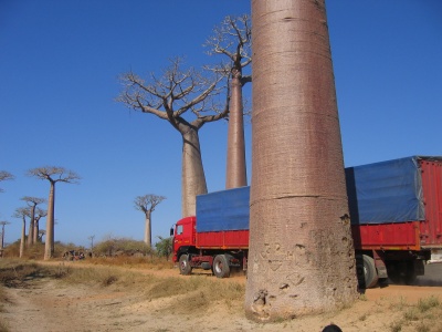
[[Image:Baobab_Avenue_006.jpg|400px|right]] | [[Image:Baobab_Avenue_006.jpg|400px|right]] | ||
| − | Baobab Avenue, also known as Allée de Baobab, is a cluster of baobab trees stretching approximately 100 metres, about 15 kilometres east of Morondava | + | Baobab Avenue, also known as Allée de Baobab, is a cluster of baobab trees stretching approximately 100 metres, located about 15 kilometres east of Morondava along the road towards [[Thingy|The Thingy]]. |
Baobab Avenue is a popular stop-by for tourists to photograph and can be found on many postcards of Madagascar. There is a small village and a school nearby which welcome visiting tourists. | Baobab Avenue is a popular stop-by for tourists to photograph and can be found on many postcards of Madagascar. There is a small village and a school nearby which welcome visiting tourists. | ||
The [[baobab tree]] is the national tree of Madagascar. | The [[baobab tree]] is the national tree of Madagascar. | ||
Revision as of 21:45, 22 March 2009
Baobab Avenue, also known as Allée de Baobab, is a cluster of baobab trees stretching approximately 100 metres, located about 15 kilometres east of Morondava along the road towards The Thingy.
Baobab Avenue is a popular stop-by for tourists to photograph and can be found on many postcards of Madagascar. There is a small village and a school nearby which welcome visiting tourists.
The baobab tree is the national tree of Madagascar.
