Difference between revisions of "Sambirano River crossing by foot"
| (5 intermediate revisions by the same user not shown) | |||
| Line 1: | Line 1: | ||
'''A couple of walking minutes leaving [[Antsirasira]] upstream the Sambirano River, the river makes a huge turn. To reach the village of [[Marovato]] it is best to cross the river by foot or pirogue.''' | '''A couple of walking minutes leaving [[Antsirasira]] upstream the Sambirano River, the river makes a huge turn. To reach the village of [[Marovato]] it is best to cross the river by foot or pirogue.''' | ||
| − | + | {| class="imageTable" | |
| − | -13.940492, 48.553775 | + | |- |
| − | [[Antsirasira]] | + | |colspan="3" | [[File:Sambirano_River_crossing_by_foot_002.jpg|600px]] |
| − | -13.931072, 48.566292 | + | |- |
| − | + | |[[File:Sambirano_River_crossing_by_foot_008.jpg|196px]] | |
| − | -13.94711, 48.554842 | + | |align="center"|[[File:Sambirano_River_crossing_by_foot_009.jpg|196px]] |
| − | [[Marovato_(Ambanja)|Marovato]] | + | |align="right"|[[File:Sambirano_River_crossing_by_foot_010.jpg|196px]] |
| − | </ | + | |} |
| + | |||
| + | People living in this area are mostly cacao farmers. Their countless plantations stretch along the shores of the [[Sambirano River]]. | ||
| + | |||
| + | {| class="imageTable" | ||
| + | |- | ||
| + | |colspan="3" | [[File:Sambirano_River_crossing_by_foot_015.jpg|600px]] | ||
| + | |- | ||
| + | |[[File:Sambirano_River_crossing_by_foot_013.jpg|196px]] | ||
| + | |align="center"|[[File:Sambirano_River_crossing_by_foot_014.jpg|196px]] | ||
| + | |align="right"|[[File:Sambirano_River_crossing_by_foot_016.jpg|196px]] | ||
| + | |} | ||
| + | |||
| + | <div style="max-width:600px;"> | ||
| + | {{#display_map: | ||
| + | -13.940492, 48.553775~'''[[Antsirasira]]'''~~; | ||
| + | -13.931072, 48.566292~'''Sambirano river crossing by foot'''~~; | ||
| + | -13.94711, 48.554842~'''[[Marovato_(Ambanja)|Marovato]]'''~~; | ||
| + | |type=satellite | ||
| + | |service=google | ||
| + | |width=auto | ||
| + | |height=400 | ||
| + | |zoom=13 | ||
| + | |controls=pan, zoom, type, scale | ||
| + | |copycoords=yes | ||
| + | |icon=https://www.madacamp.com/images/madagascar/Green_marker.png | ||
| + | }} | ||
| + | </div> | ||
'''GPS coordinates'''<br> | '''GPS coordinates'''<br> | ||
| − | Google: 13°56'62.4"S 48°34'13.2"E | + | Google: 13°56'62.4"S 48°34'13.2"E<br> |
Garmin: -13.94711, 48.554842 | Garmin: -13.94711, 48.554842 | ||
| + | == Photos == | ||
| + | |||
| + | View all [[Sambirano River crossing by foot photos]] | ||
| + | |||
| + | == Additional information == | ||
| − | |||
| − | |||
* [[Sambirano Trekking Tour]] | * [[Sambirano Trekking Tour]] | ||
Latest revision as of 06:11, 23 December 2020
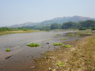
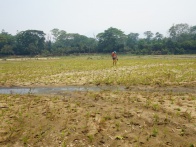
A couple of walking minutes leaving Antsirasira upstream the Sambirano River, the river makes a huge turn. To reach the village of Marovato it is best to cross the river by foot or pirogue.

| ||
|
|

|
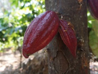
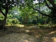
People living in this area are mostly cacao farmers. Their countless plantations stretch along the shores of the Sambirano River.
| ||
|
|
|
Loading map...
GPS coordinates
Google: 13°56'62.4"S 48°34'13.2"E
Garmin: -13.94711, 48.554842