Difference between revisions of "Sambava to Antalaha by bike"
| (2 intermediate revisions by the same user not shown) | |||
| Line 1: | Line 1: | ||
| − | Starting at [[Resto Mimi]], a bit before Sambava Centre, ending at Flao Plage, this approximately 6.5 hours bike ride at an average speed of 12km p/hour leads along a mostly straight and tarred road in excellent condition with minimal traffic. | + | '''Starting at [[Resto Mimi]], a bit before Sambava Centre, ending at Flao Plage, this approximately 6.5 hours bike ride at an average speed of 12km p/hour leads along a mostly straight and tarred road in excellent condition with minimal traffic.''' |
| − | Shortly after [[Soavoanio]] coconut distillery on the left is the village of [[Antohomaro]] | + | Shortly after [[Soavoanio]] coconut distillery on the left is the village of [[Antohomaro]]. |
<!-- | <!-- | ||
-14.415217, 50.167417 | -14.415217, 50.167417 | ||
| Line 48: | Line 48: | ||
[[Antalaha]] | [[Antalaha]] | ||
--> | --> | ||
| + | |||
| + | [[File:Sambava-Antalaha-bike-map.jpg|link=Sambava-Antalaha by bike map]] | ||
== Tour data == | == Tour data == | ||
| Line 59: | Line 61: | ||
Maximum elevation: 27 metres | Maximum elevation: 27 metres | ||
| − | [[ | + | == Places of interest == |
| + | |||
| + | Swimming spot at Lake Andohabe | ||
| + | |||
| + | [[Mimi Hotel]]<br> | ||
| + | -14.2582259886,50.1451830659 | ||
| + | |||
| + | [[Soavoanio]] coco distillery<br> | ||
| + | -14.318250, 50.187667 | ||
| + | |||
| + | [[Antohomaro]]<br> | ||
| + | -14.327350, 50.185200 | ||
| + | |||
| + | [[Antanandava]]<br> | ||
| + | -14.415217, 50.167417 | ||
| + | |||
| + | Thé-Cola NANA<br> | ||
| + | -14.418917, 50.166233 | ||
| + | |||
| + | [[Farahalana]]<br> | ||
| + | -14.429559, 50.156202 | ||
| + | |||
| + | [[Amboronala]]<br> | ||
| + | -14.526700, 50.166617 | ||
| + | |||
| + | [[Ambodimanga]]<br> | ||
| + | -14.571950, 50.165833 | ||
| + | |||
| + | [[Ampanatsoavana]]<br> | ||
| + | -14.599300, 50.171133 | ||
| + | |||
| + | [[Ambodipont Isahana]]<br> | ||
| + | -14.617717, 50.181233 | ||
| + | |||
| + | [[Anboangy]]<br> | ||
| + | -14.658533, 50.206467 | ||
| + | |||
| + | [[Andrapengy]]<br> | ||
| + | -14.675117, 50.215450 | ||
| + | |||
| + | [[Jaovato]]<br> | ||
| + | -14.709600, 50.221083 | ||
| + | |||
| + | [[Tampoly]]<br> | ||
| + | -14.730500, 50.217967 | ||
| + | |||
| + | [[Ampahana]]<br> | ||
| + | -14.760283, 50.219683 | ||
| + | |||
| + | [[Antseranabidy]]<br> | ||
| + | -14.777583, 50.230383 | ||
| + | |||
| + | [[Flao Plage]]<br> | ||
| + | -14.8512671795, 50.2609121706 | ||
| + | |||
| + | [[Antalaha]]<br> | ||
| + | -14.9024083558, 50.278910799 | ||
== Photos == | == Photos == | ||
| Line 68: | Line 126: | ||
More bike routes and bicycle rental: [http://www.Madabike.com Madabike.com] | More bike routes and bicycle rental: [http://www.Madabike.com Madabike.com] | ||
| + | |||
| + | __NOTOC__ | ||
Revision as of 08:36, 3 December 2020
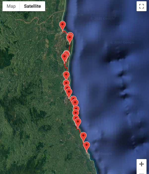
Starting at Resto Mimi, a bit before Sambava Centre, ending at Flao Plage, this approximately 6.5 hours bike ride at an average speed of 12km p/hour leads along a mostly straight and tarred road in excellent condition with minimal traffic.
Shortly after Soavoanio coconut distillery on the left is the village of Antohomaro.
Tour data
Sambava - Flao Plage 77.8 km
Flao Plage - Antalaha 7 km
Date: June 2020
Distance: 84.8 km
Minimum elevation: 7 metres
Maximum elevation: 27 metres
Places of interest
Swimming spot at Lake Andohabe
Mimi Hotel
-14.2582259886,50.1451830659
Soavoanio coco distillery
-14.318250, 50.187667
Antohomaro
-14.327350, 50.185200
Antanandava
-14.415217, 50.167417
Thé-Cola NANA
-14.418917, 50.166233
Farahalana
-14.429559, 50.156202
Amboronala
-14.526700, 50.166617
Ambodimanga
-14.571950, 50.165833
Ampanatsoavana
-14.599300, 50.171133
Ambodipont Isahana
-14.617717, 50.181233
Anboangy
-14.658533, 50.206467
Andrapengy
-14.675117, 50.215450
Jaovato
-14.709600, 50.221083
Tampoly
-14.730500, 50.217967
Ampahana
-14.760283, 50.219683
Antseranabidy
-14.777583, 50.230383
Flao Plage
-14.8512671795, 50.2609121706
Antalaha
-14.9024083558, 50.278910799
Photos
View all Sambava to Antalaha by bike photos
Madabike
More bike routes and bicycle rental: Madabike.com